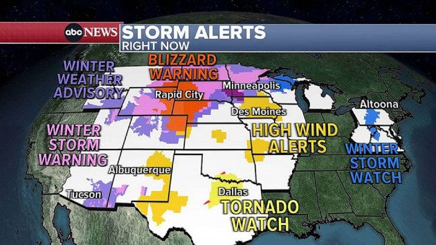
Winter storm latest: Blizzard warning in the north, tornado threat in the south
(NEW YORK) — A major winter storm is pushing east, bringing heavy snow, ice and blizzard conditions to the north and tornadoes the south.
Here’s the forecast for the week:
Tuesday
Blizzard warnings were issued in Montana, South Dakota, Nebraska, Wyoming, Kansas and Colorado as heavy snow and strong winds hammer the region.
One to two feet of snow is expected through Thursday. Coupled with winds near 55 mph, residents could see dangerous whiteout conditions.
Ten inches of snow has been reported so far in South Dakota, with more to come. South Dakota’s Department of Transportation said it’s closing over 200 miles of Interstate 90 due to the expected freezing rain, heavy snow and high winds.
Meanwhile, tornadoes touched down in Oklahoma and Texas on Tuesday.
On Tuesday night, the tornado threat will extend from Texas to Mississippi.
A “large and extremely dangerous tornado” was confirmed about 14 miles west of Shreveport Tuesday afternoon, the National Weather Service of Shreveport said. A tornado warning was issued for the area until 4:30 p.m. local time.
Wednesday
The tornado threat moves into the central Gulf Coast on Wednesday. The strongest storms will be around Jackson, Mississippi; New Orleans; and Mobile, Alabama.
Thursday
The Florida Peninsula may see severe storms Thursday morning.
Meanwhile, snow will start in Pennsylvania on Thursday morning and will continue falling in the inland Northeast through Saturday. More than 1 foot of snow is possible from Pennsylvania to Maine.
Rain will move into New York City Thursday afternoon and last until Friday night. One to 2 inches is expected.
ABC News’ Kenton Gewecke and Alex Faul contributed to this report.
Copyright (C) 2022, ABC Audio. All rights reserved.